
Northern Arizona holds some of America’s most breathtaking canyon scenery, with dramatic red rock formations and the mighty Colorado River carving spectacular landscapes. The stretch between Page and Marble Canyon offers visitors an incredible collection of viewpoints, from world-famous overlooks to hidden gems that showcase nature’s artistry. Whether you’re seeking easy walks or challenging hikes, this region delivers unforgettable vistas that will leave you amazed by the power of water and time.
1. Horseshoe Bend Overlook (Page)
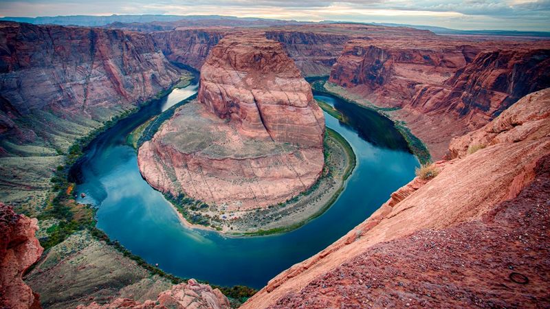
Picture the Colorado River making a perfect horseshoe turn through towering sandstone cliffs, and you’ll understand why millions of visitors flock to this iconic spot. The 1.5-mile round-trip trail from the parking area might seem easy, but the desert terrain can be challenging in summer heat.
Early morning and late evening visits offer cooler temperatures and softer lighting that makes the red rocks glow like fire. The overlook sits 1,000 feet above the river, providing heart-stopping views that photographers dream about.
Bring plenty of water and stay back from the unfenced edge for safety.
2. Glen Canyon Dam Overlook (Page)
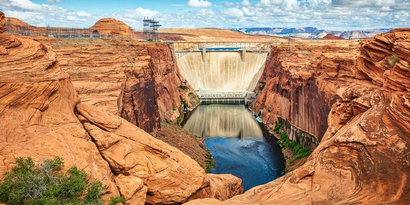
Just a short 940-foot walk from downtown Page leads to one of the most impressive engineering views in the Southwest. The massive concrete dam stretches across Glen Canyon like a giant wall, holding back the waters of Lake Powell behind it.
Standing at the railed viewpoint, you’ll peer down at the Colorado River far below while the dam towers upstream in all its concrete glory. This quick stop delivers spectacular canyon views without requiring a long hike or desert trek.
The overlook stays accessible year-round and offers protected viewing even during windy weather conditions.
3. The Chains Slickrock (Page)
Smooth sandstone ledges directly across from Glen Canyon Dam provide intimate views into the heart of the canyon system. The slickrock formations create natural viewing platforms where you can sit and watch the play of light and shadow on canyon walls.
When lake levels permit, this spot offers legal access to Lake Powell’s waters for swimming or kayaking. The signed turnoff just east of the dam makes finding this hidden gem relatively easy for those in the know.
Wear shoes with good grip since the smooth rock surfaces can become slippery, especially when wet from morning dew.
4. Hanging Garden Trail (Page)
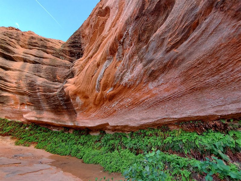
Desert landscapes suddenly give way to lush green oases where water seeps from canyon walls, creating magical hanging gardens. This short trail leads to a verdant alcove where ferns, mosses, and wildflowers thrive in the desert’s embrace.
The contrast between harsh desert and delicate garden plants creates a photographer’s paradise, while expansive views of surrounding canyon country stretch toward the horizon. Near Glen Canyon Bridge, this easily accessible trail offers big rewards for minimal effort.
Please respect the fragile ecosystem by staying on designated paths and avoiding stepping on the delicate vegetation that takes years to establish.
5. Page Rim View Trail Pullouts (Page)
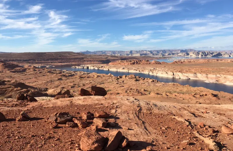
Multiple access points around Page’s mesa rim provide convenient stops for canyon viewing when weather makes longer hikes unpleasant. These pullouts offer sweeping panoramas toward Glen Canyon Dam, the winding river corridor, and Lake Powell’s blue waters.
Perfect for windy days or light rain when you still crave those incredible vistas, these viewpoints require minimal walking from your vehicle. Each pullout provides slightly different perspectives of the dramatic landscape carved by millions of years of flowing water.
The elevated mesa position creates natural wind protection while maintaining excellent visibility across the entire canyon system below.
6. Glen Canyon Dam Bridge Walk (US-89 at the dam)
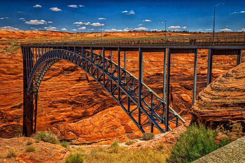
Walking across this steel arch bridge delivers vertigo-inducing views straight down into Glen Canyon’s depths. The pedestrian sidewalk allows safe passage while providing unobstructed sightlines toward the massive dam structure and canyon walls.
Starting near the Carl Hayden Visitor Center, this unique vantage point combines engineering marvel with natural wonder. Few places let you stand suspended high above such dramatic canyon scenery while cars rush past just feet away.
The bridge walk works perfectly for visitors who want spectacular views without hiking desert trails or climbing steep paths to remote overlooks.
7. Navajo Bridge & Interpretive Center (Marble Canyon)
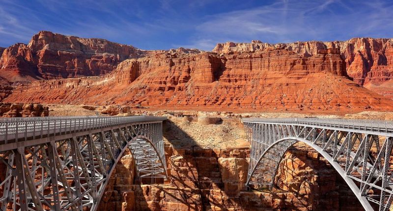
Two bridges span Marble Canyon here – the historic 1929 span now serves pedestrians while modern traffic uses the newer crossing beside it. Walking the original bridge provides classic canyon views and excellent opportunities for spotting California condors.
These massive birds with nine-foot wingspans often ride thermal currents rising from the canyon depths, creating unforgettable wildlife viewing moments. The interpretive center explains both bridge construction history and condor recovery efforts.
Marble Canyon’s sheer walls and the Colorado River flowing 470 feet below create a dramatic backdrop for photography and quiet contemplation of this engineering achievement.
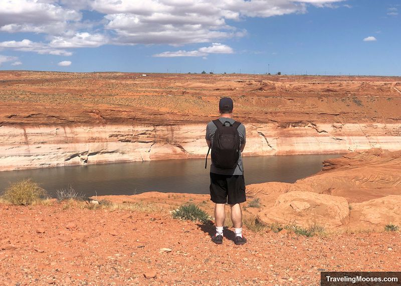
8. Lees Ferry River Access (Marble Canyon)
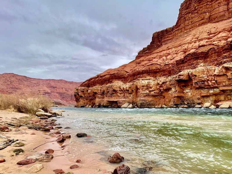
Nowhere else in nearly 700 miles of canyon country can you actually drive down to touch the Colorado River’s waters. This unique access point sits precisely where Glen Canyon ends and Grand Canyon begins.
River-level perspectives reveal the true scale of surrounding canyon walls while providing opportunities to watch river runners preparing for Grand Canyon adventures. The broad views encompass towering cliffs, desert vegetation, and the powerful river that carved this entire landscape.
Historical significance adds depth to your visit, as this crossing served travelers, miners, and settlers for over a century before modern bridges existed.
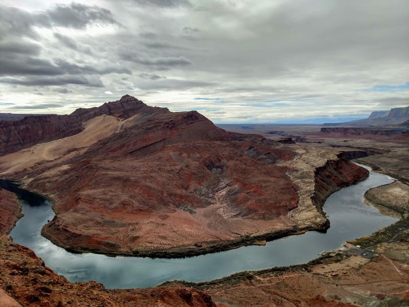
9. Paria Riffle / Paria-Colorado Confluence (Lees Ferry)
Watch two rivers tell different stories as the muddy Paria River joins the clear Colorado, creating visible boundaries between silty brown and blue-green waters. This confluence forms the Paria Riffle, the first real turbulence that downstream river runners encounter.
The mixing waters create fascinating patterns and colors that change with seasons, rainfall, and flow levels. Photographers find endless subjects in the swirling currents and contrasting water colors.
This easily accessible spot provides perfect introduction to river dynamics and hydrology while offering excellent opportunities for contemplating the power of flowing water in desert landscapes.
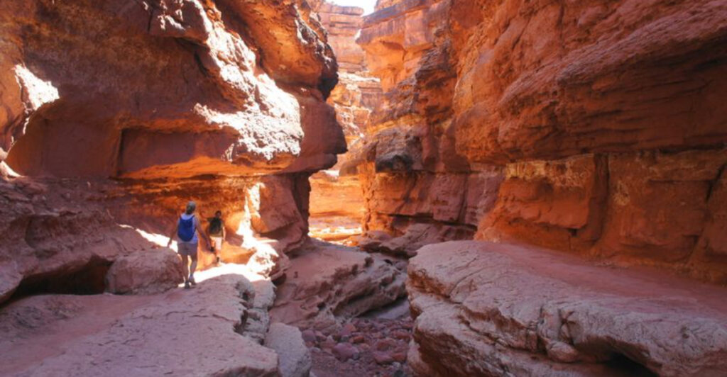
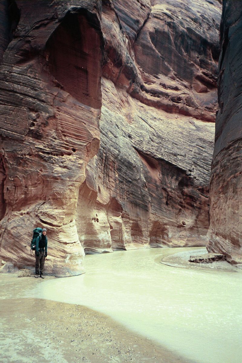
10. Cathedral Wash to Marble Canyon (Lees Ferry)
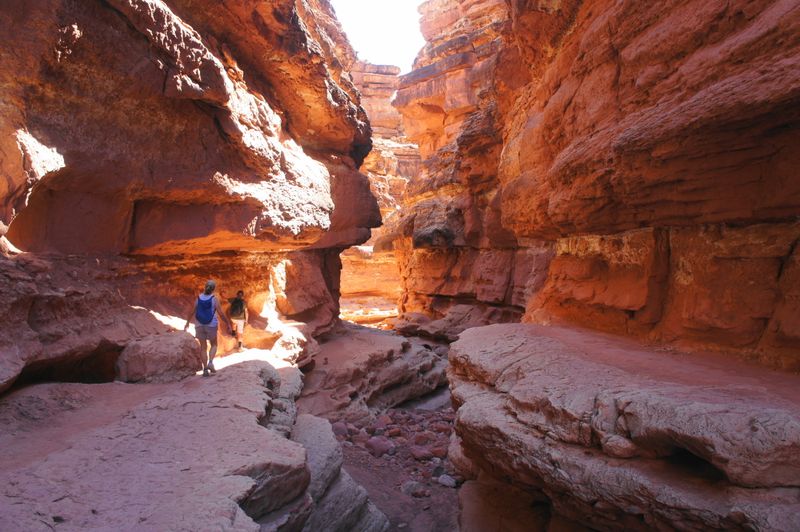
Sculpted narrows guide you through a moderate canyon walk toward the Colorado River, with towering walls creating cathedral-like spaces overhead. Even gray, overcast days produce dramatic lighting effects as filtered sunlight bounces between smooth sandstone surfaces.
The wash demonstrates flash flood power through its carved channels and polished walls, while providing intimate views of geological layers and desert adaptation. Photography opportunities abound in the play of light and shadow.
Exercise caution around drop-offs and avoid this hike during thunderstorm season when flash floods can fill narrow washes with dangerous, fast-moving water within minutes.
11. Spencer Trail Overlook (Lees Ferry)
Historic switchbacks climb steeply for 4.4 miles round-trip to deliver some of the region’s most expansive panoramic views. From the rim, Marble Canyon spreads below while the Paria Plateau extends toward distant horizons, with Page visible on clear days.
This challenging hike follows routes used by early settlers and surveyors, adding historical context to your physical achievement. Spring and fall provide ideal hiking conditions, while summer heat makes this trek dangerous.
Huge panoramas reward your effort with perspectives impossible to achieve from roadside viewpoints, encompassing thousands of square miles of canyon country in a single sweeping vista.
12. Guided Antelope Canyon Tour (Page – short detour)
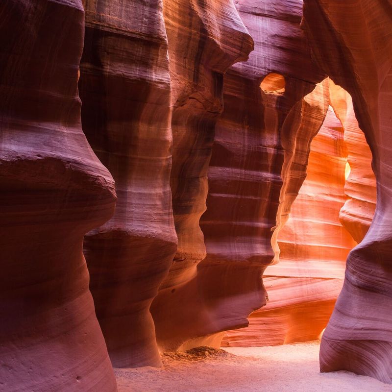
World-famous slot canyon tours provide shelter during bad weather while delivering some of Earth’s most photographed underground scenery. Mandatory Navajo guides lead visitors through either Upper or Lower Antelope Canyon’s narrow passages.
Sculpted sandstone walls create otherworldly chambers where filtered sunlight creates magical beams and glowing colors. Advanced reservations are essential, especially during peak seasons when tours fill months ahead.
These technical slot canyons require authorized guides for safety and cultural respect, but the experience of walking through nature’s underground art gallery makes the planning effort absolutely worthwhile for any canyon country visitor.

