
Fire-breathing mountains dot the Pacific Northwest landscape like sleeping giants, each one capable of unleashing devastating power.
These volcanic peaks aren’t just scenic backdrops for Instagram photos—they’re active geological forces that could dramatically reshape entire regions.
From Washington’s glaciated peaks to California’s explosive calderas, these thirteen volcanoes represent some of North America’s most dangerous natural threats.
1. Mount Rainier – Washington’s Glaciated Giant
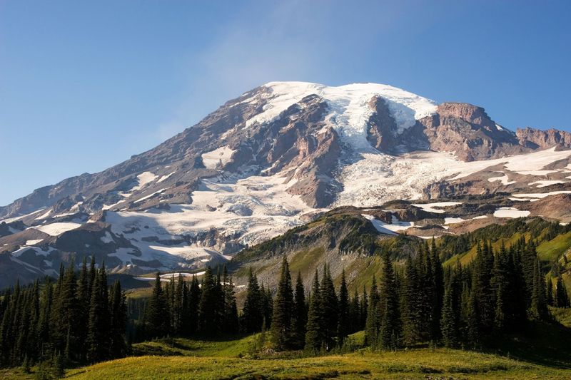
Towering at 14,410 feet above sea level, Mount Rainier commands respect as the Pacific Northwest’s most dangerous volcanic threat. What makes this sleeping giant particularly terrifying isn’t just its potential for explosive eruptions—it’s the massive glacial ice coating its slopes.
When Rainier eventually awakens, these glaciers will melt rapidly, creating catastrophic lahars that could devastate communities like Orting and Puyallup. These volcanic mudflows move faster than most people can run, carrying the destructive force of liquid concrete.
Scientists continuously monitor this stratovolcano because over 150,000 people live in areas that would face direct lahar threats during an eruption.
2. Mount St. Helens – The Explosive Comeback Kid
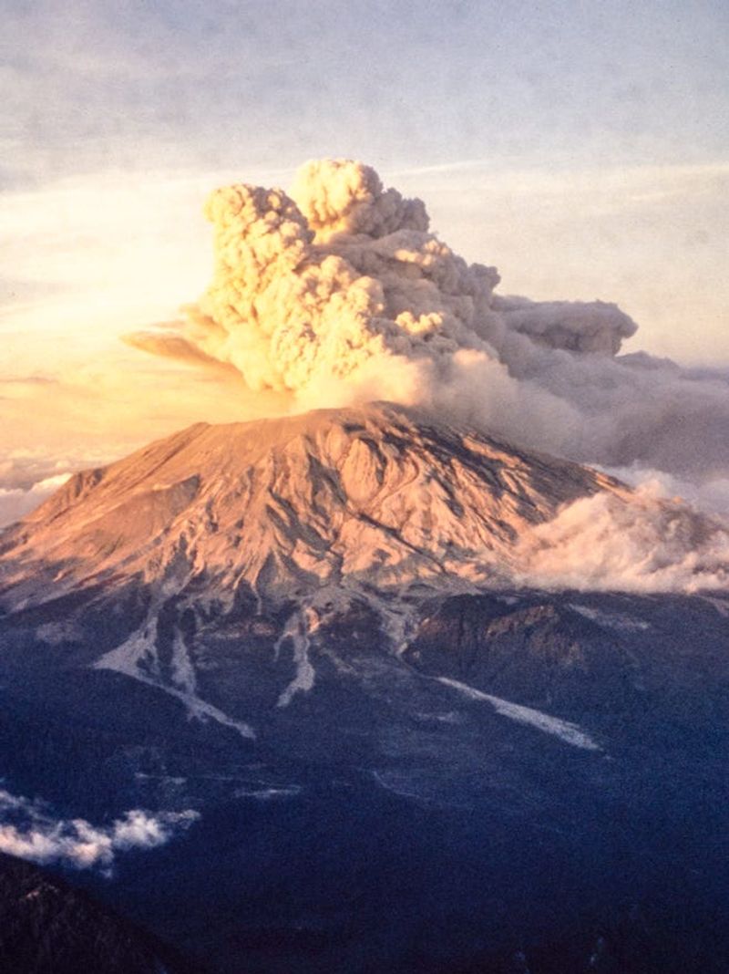
May 18, 1980, changed everything we thought we knew about volcanic eruptions in America. Mount St. Helens literally blew its top off, sending ash across multiple states and reducing its height by over 1,300 feet in a single catastrophic moment.
Today, this active dome-building volcano continues its dangerous dance of destruction and creation. Steam vents hiss ominously from its crater, while a new lava dome slowly grows inside the horseshoe-shaped crater left by that infamous blast.
Geologists watch St. Helens closely because it remains one of the most active volcanoes in the Cascade Range, capable of repeating its explosive performance with little warning.
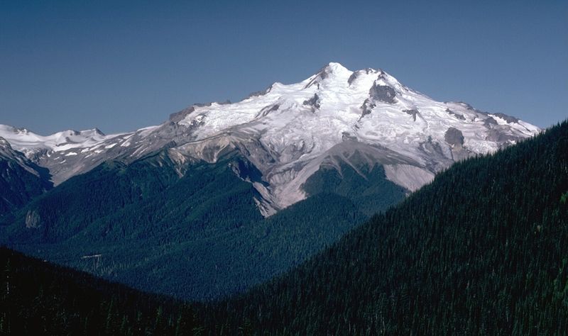
3. Mount Baker – The Northern Sentinel
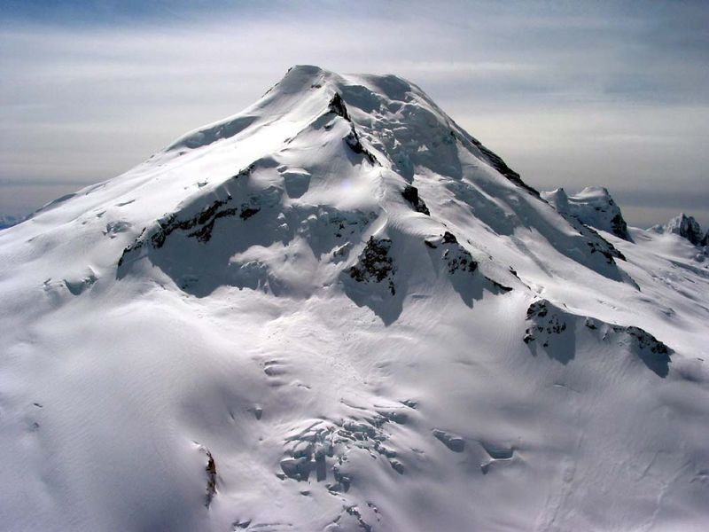
Steam rises mysteriously from Mount Baker’s summit crater, creating an otherworldly scene that hints at the volcanic fires burning beneath its icy exterior. Located just 30 miles from the Canadian border, this 10,781-foot stratovolcano last erupted in 1880 but shows no signs of permanent slumber.
Fumaroles continuously vent hot gases through the mountain’s glacial cap, creating ice caves and thermal features that attract both scientists and adventurers. However, these same glaciers pose significant lahar risks to downstream communities in the Skagit and Nooksack river valleys.
Baker’s remote location makes detailed monitoring challenging, yet its proximity to populated areas keeps volcanologists vigilant for signs of renewed activity.
4. Glacier Peak – The Hidden Explosive
Don’t let its remote location fool you—Glacier Peak ranks among the most explosively dangerous volcanoes in North America. This 10,541-foot giant hides deep in the North Cascades wilderness, making it less famous than its volcanic siblings but potentially more devastating.
Historical evidence reveals Glacier Peak’s violent past, including massive ash-producing eruptions that blanketed areas hundreds of miles away. Its last major eruption around 1700 AD sent pyroclastic flows racing down its flanks and ash clouds drifting across the continent.
The mountain’s isolated location makes real-time monitoring difficult, creating a dangerous blind spot in our volcanic surveillance network. When Glacier Peak decides to awaken, its explosive potential could surprise everyone.
5. Mount Hood – Oregon’s Towering Threat
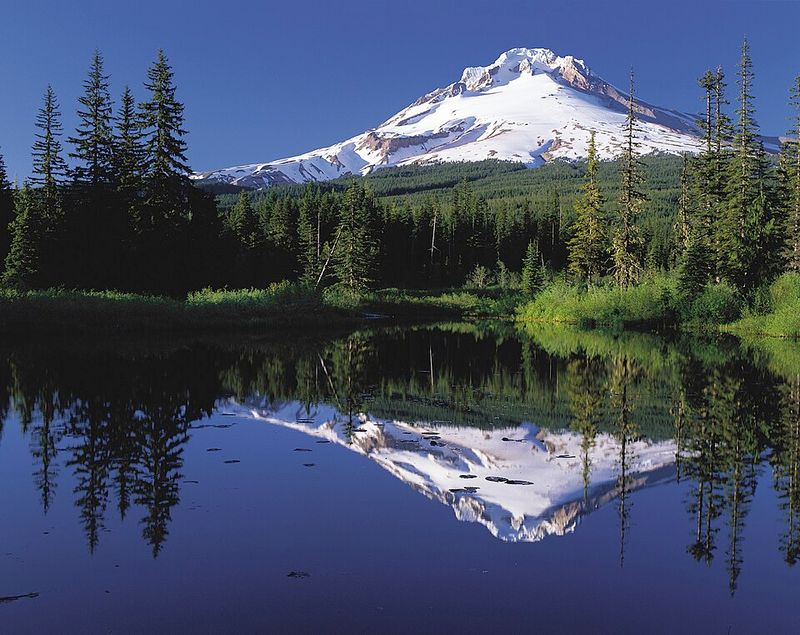
Oregon’s tallest peak at 11,240 feet, Mount Hood looms majestically over Portland’s skyline like a postcard-perfect guardian. But this stratovolcano’s beauty masks a dangerous reality—it last erupted around 1781, and geological evidence suggests it’s overdue for its next performance.
Hood’s proximity to over two million people makes it one of America’s highest-risk volcanoes. Lahar pathways follow the Sandy and Hood rivers directly toward populated areas, potentially threatening communities, highways, and critical infrastructure.
Scientists have identified at least three major eruptive periods in Hood’s recent geological history. Each cycle produced pyroclastic flows, lahars, and ash falls that dramatically altered the surrounding landscape and river systems.
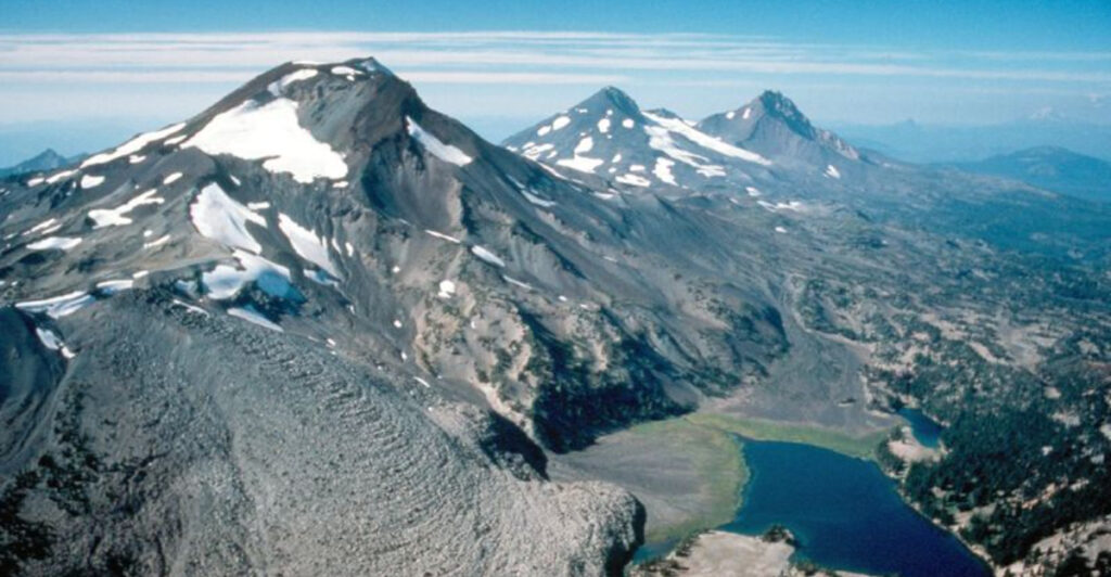
6. Three Sisters – Oregon’s Restless Trio
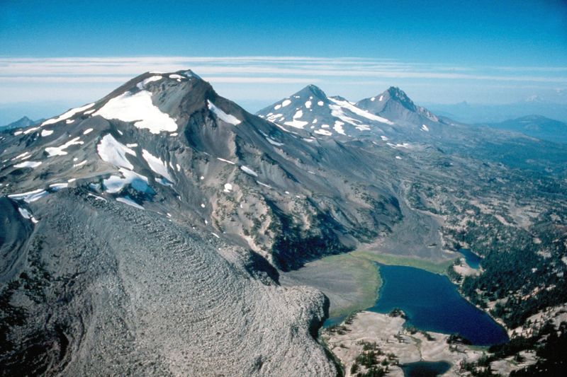
South Sister has been literally rising from her slumber, with ground deformation measurements showing the volcano has lifted nearly eight inches since 1996. This geological awakening has scientists paying close attention to Oregon’s Three Sisters volcanic complex.
The youngest of the trio, South Sister last erupted about 2,000 years ago, creating the region’s distinctive obsidian flows and cinder cones. Meanwhile, her older siblings—North and Middle Sister—stand as weathered sentinels, reminders of the area’s explosive volcanic heritage.
Seismic activity and ground uplift suggest magma movement beneath the surface. While no immediate eruption threat exists, the Sisters demonstrate how volcanic systems can reawaken after millennia of apparent dormancy.
7. Newberry Volcano – The Geothermal Powerhouse
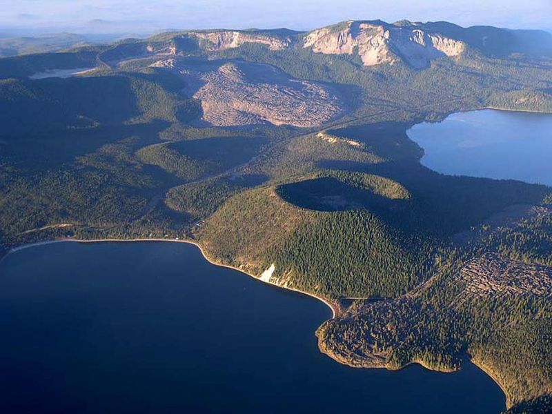
Newberry Volcano doesn’t look like most people’s idea of a dangerous mountain—this massive shield volcano spreads across 500 square miles of central Oregon landscape. Its broad, gentle slopes hide one of the region’s most active volcanic systems, complete with hot springs, obsidian flows, and a large summit caldera.
Paulina Lake and East Lake fill the volcano’s caldera, creating a deceptively peaceful scene above an active magma chamber. Hot springs bubble along the shorelines, while recent obsidian flows demonstrate the volcano’s continued activity within the last 1,300 years.
Geothermal energy companies tap into Newberry’s underground heat, but this same thermal activity reminds us that molten rock lies relatively close to the surface, ready to create future eruptions.
8. Crater Lake (Mount Mazama) – The Collapsed Giant
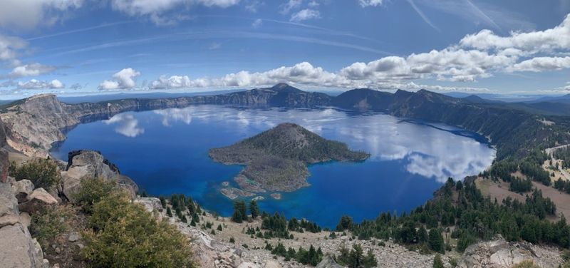
Crater Lake’s impossibly blue waters fill the remains of Mount Mazama, a volcano that literally collapsed into itself during a catastrophic eruption 7,700 years ago. That ancient blast was so powerful it sent ash as far as Canada and created the six-mile-wide caldera we see today.
While technically dormant, Mazama’s volcanic system remains active beneath the lake’s pristine surface. Hydrothermal vents warm the lake bottom, and occasional earthquake swarms remind scientists that this sleeping giant isn’t completely dead.
Wizard Island, rising from the lake’s western shore, represents post-collapse volcanic activity. This small cinder cone proves that Mount Mazama’s story isn’t over—it’s simply paused between chapters of geological drama.
9. Mount Shasta – California’s Massive Stratovolcano

Rising 14,162 feet above Northern California, Mount Shasta commands attention as one of the Cascade Range’s most imposing volcanic peaks. This massive stratovolcano hasn’t erupted since 1786, but its size and explosive history make it a significant regional threat.
Shasta’s volcanic system includes multiple overlapping cones and domes, evidence of complex eruption patterns spanning hundreds of thousands of years. Shastina, a prominent subsidiary peak, formed during explosive eruptions just a few thousand years ago.
The mountain’s isolation and size create their own weather patterns, often shrouding the peak in mysterious clouds. However, this same remoteness makes monitoring challenging, while nearby communities in the Shasta Valley would face significant risks from future pyroclastic flows and lahars.
10. Lassen Peak – The Recent Awakener
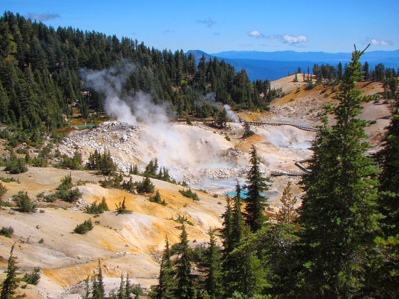
Between 1914 and 1917, Lassen Peak reminded Californians that the Cascade Range’s volcanic threats extend far south of Mount Shasta. This 10,457-foot lava dome produced spectacular explosive eruptions, sending ash clouds 30,000 feet into the atmosphere and devastating nearby forests.
Today, Lassen Volcanic National Park showcases the mountain’s continued activity through boiling mud pots, fumaroles, and hot springs. Bumpass Hell, the park’s largest hydrothermal area, demonstrates the intense heat still present beneath Lassen’s surface.
Scientists consider Lassen Peak the southernmost active volcano in the Cascade Range. Its recent eruption history and ongoing thermal features keep it on the watch list for future volcanic activity that could affect Northern California communities.
11. Yellowstone Caldera – The Supervolcano
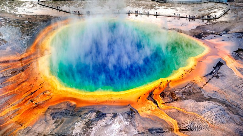
Yellowstone isn’t just a national park—it’s one of the world’s largest active volcanic systems, capable of eruptions that could affect global climate. This supervolcano has produced three massive caldera-forming eruptions over the past 2.1 million years, with the most recent occurring 640,000 years ago.
Geysers, hot springs, and mud pots across Yellowstone’s landscape reveal the immense magma chamber lurking beneath the park. Ground deformation and earthquake swarms provide ongoing reminders of the geological forces at work underground.
While the probability of a supereruption remains extremely low, even a smaller eruption could devastate regional communities and disrupt agriculture across multiple states. Scientists continuously monitor this sleeping giant through sophisticated seismic and thermal surveillance networks.
12. Long Valley Caldera – California’s Restless Giant
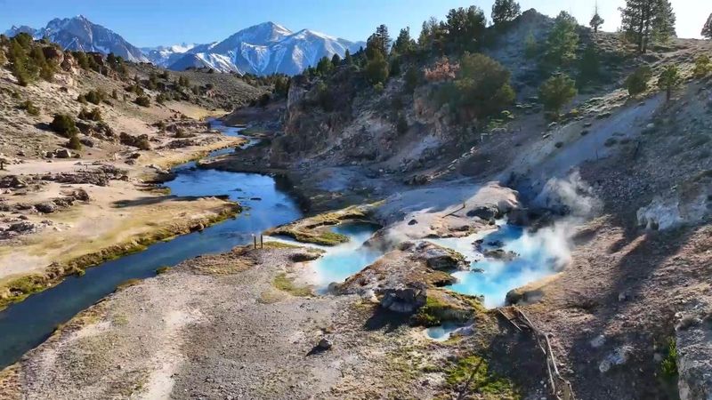
Long Valley Caldera near Mammoth Lakes, California, represents one of North America’s most closely monitored volcanic systems. This 20-mile-long, 11-mile-wide depression formed during a catastrophic eruption 760,000 years ago that ejected enough material to bury the entire state of Rhode Island under 10 feet of volcanic debris.
Recent decades have brought increased seismic activity, ground uplift, and changes in gas emissions from local hot springs. The nearby Mammoth Mountain ski area sits atop volcanic domes that have killed trees through carbon dioxide emissions.
While scientists don’t expect an imminent large eruption, Long Valley’s restless behavior keeps the U.S. Geological Survey alert for signs of escalating volcanic unrest that could threaten Eastern Sierra communities.
13. Medicine Lake Volcano – The Hidden Shield
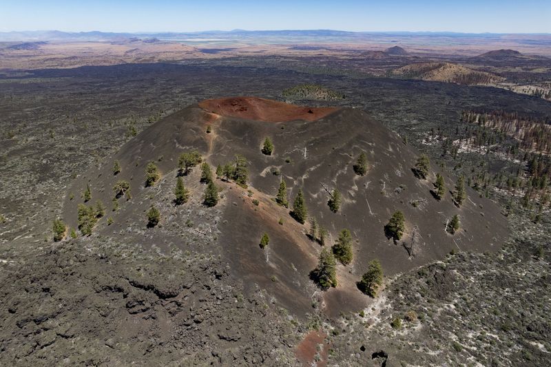
Medicine Lake Volcano doesn’t fit most people’s mental image of a dangerous mountain. This massive shield volcano in northeastern California spreads across 770 square miles, making it one of the largest volcanoes in the Cascade Range by area, despite its relatively low profile.
Recent volcanic activity includes obsidian flows and cinder cones that formed within the last 1,000 years. The volcano’s broad, gentle slopes hide a complex system of vents, domes, and lava flows that demonstrate ongoing geological activity.
Scientists have detected signs of unrest including earthquake swarms and ground deformation. While Medicine Lake remains relatively unknown compared to its famous volcanic neighbors, its size and recent activity patterns suggest it deserves serious attention from volcanic monitoring programs.

